

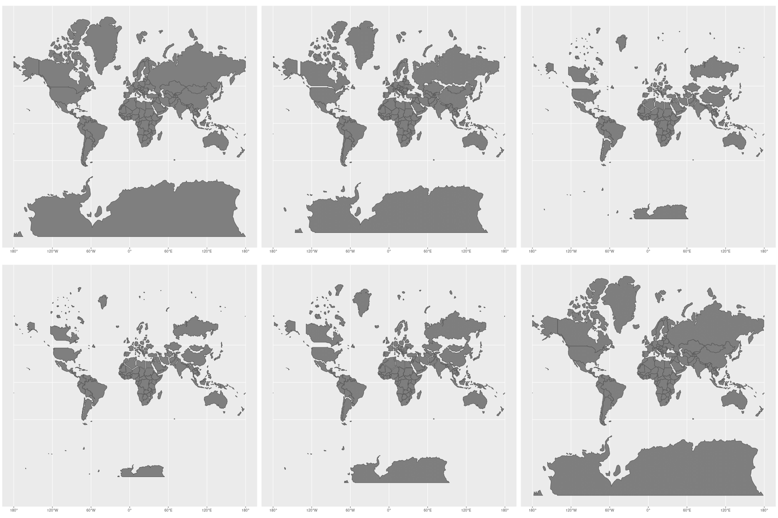
Recently the UN passed a resolution, brought to the assembly by Togo, to eventually stop using the traditional Mercator map of the globe (the one you’re probably used to) and replace it with one that aims to represent an accurate relative scale of each of the territories. (As shown in this snazzy little gif by Jakub Nowosad, where each state on the Mercator map gets reduced to a to its correct size.
Then a question on our discord from offworld bogil got me thinking again about how maps work in TTRPGs.
I’ve been making a lot of maps lately for our adventure book (Five Fathoms Deep), and reflecting on much they say about our worlds. They fulfil a number of functions at once, while being incredibly loaded (but we’ll come to that).
Why we map
Maps define an area of interest. We’ll often find that in adventures, the wilderness will be mapped by abstractions, like an atmospheric area map or colourful hex map, maybe overlaid by a point map, showing significant locations and standard or fast routes, like roads or shipping lanes. They sometimes show relative distance, either through the accuracy of the design, or through words written on the map itself. Then when you enter a specific point, like a dungeon, it’s common for the maps to become more accurate, showing rooms, maybe even salient details like furniture. They can even be gridded, a nod to the wargaming history of the hobby, or used by some games to track movement over time and relative position.
Simultaneously, however, the map is saying a lot about what the designer wants to convey about the world they’re imagining, maybe even the play-style they’re assuming. The shapes, colours, texture of marks, fonts and choice of details tells the reader a lot about the atmosphere of the space, and how they are supposed to read and use this information. A grid structure implies that this is a place to explore, where the choice of routes could make a material difference (walking over traps etc). A more abstract map implies a more abstracted playstyle, where steps are not tracked so much as imagined actions within a space. Of course, a highly diegetic style is possible with both types of map, but a tight “check-based” way of playing (think modern D&D) with gridded combat sometimes necessitates one and would have trouble with the other. This isn’t a value judgement, I’m just trying to make the point that the map says a lot about the game that the adventure designer is assuming you’ll play with their work.
Often the only contact that players have with the designed world is the map that gets handed to them, along with perhaps the cover image on the main rulebook. Players (including the GM) will infer a lot from the presentation of the map, so consider that when creating them for your adventures.
Maps are incredibly useful. They explain relative positions, scales and topology far more economically than you could ever express them with the written word. They’re a useful crutch for the process of imagining that is at the heart of TTRPGs, like a standard in jazz, a set of solid mutual understandings (like a chord sequence) that gives you the licence to improvise and embellish as GM or player (in playstyles, like in my games, that encourage such lunacy).
Some great maps
I thought I’d do an inventory of a bunch of maps I enjoy that I have in my little collection, to see if I could glean any lessons. I’ll start with a fairly conventional one, the maps in Gavin Norman’s Winter’s Daughter, by Karl Stjernberg.
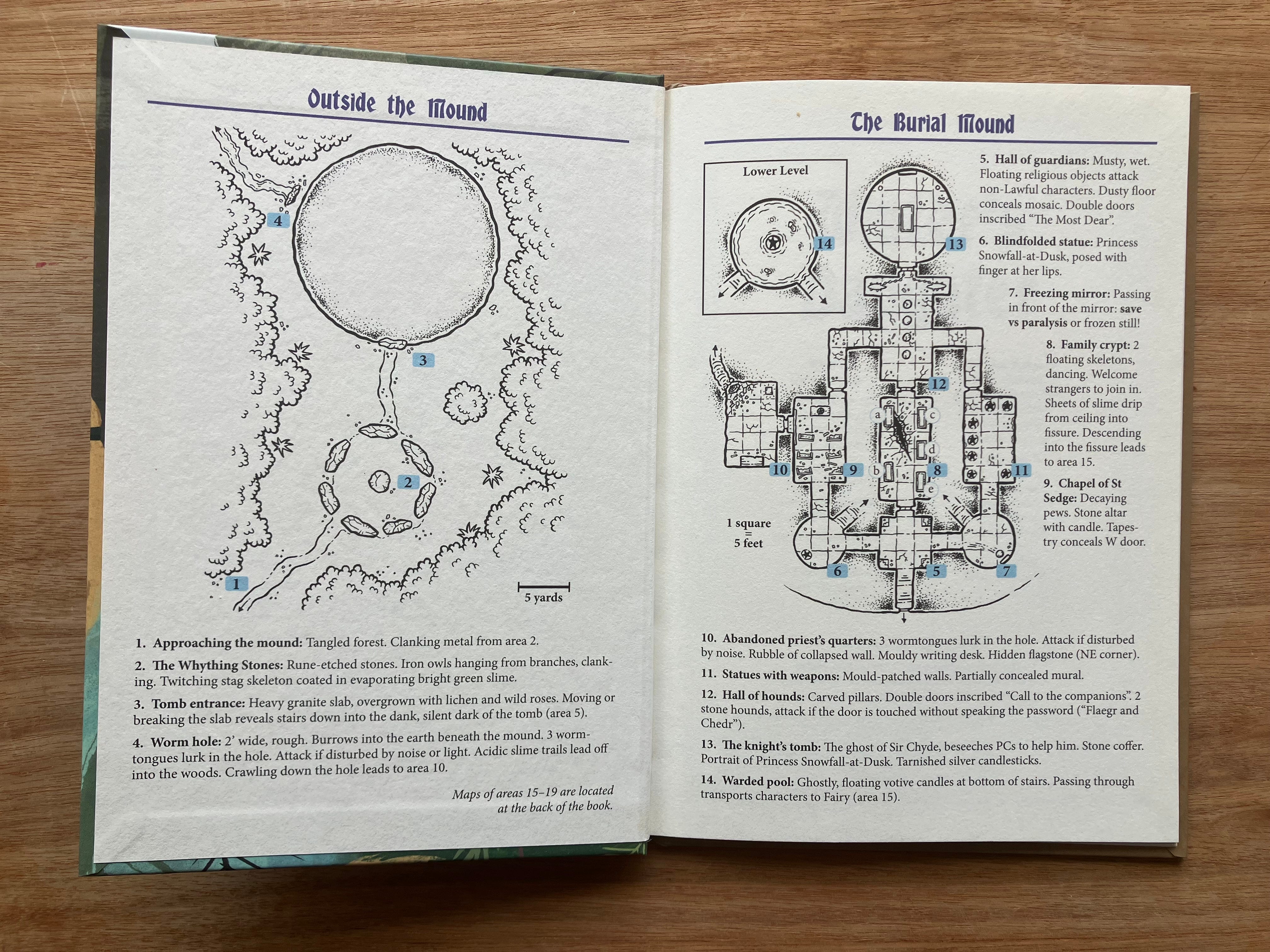
Here we have two maps in a similar style that function very differently. Outside the Mound gives an atmospheric overhead view of a glade. There are certainly important gamable details, like the directions of the paths, the circle of stones (perhaps implying a pagan or occult subtext), and there’s something whimsical about the execution–the frilly leaves, the stars in the glade (sprigs of grasses?). It sets the scene for an adventure in touch with the other-worldly.
Then right next door, describing the inside of The Burial Mound is a far more intricate and functional map, meticulously gridded, ready for OD&D step-by-step exploration. The use of stars for statues (room 11) is a convention that goes a long way back in the hobby–I remember seeing them in the maps in the Mentzer D&D red box that was my introduction to the hobby in 1986–and is totally apt for a module harking back to early roleplay, in fact codes it as such, however subliminally.
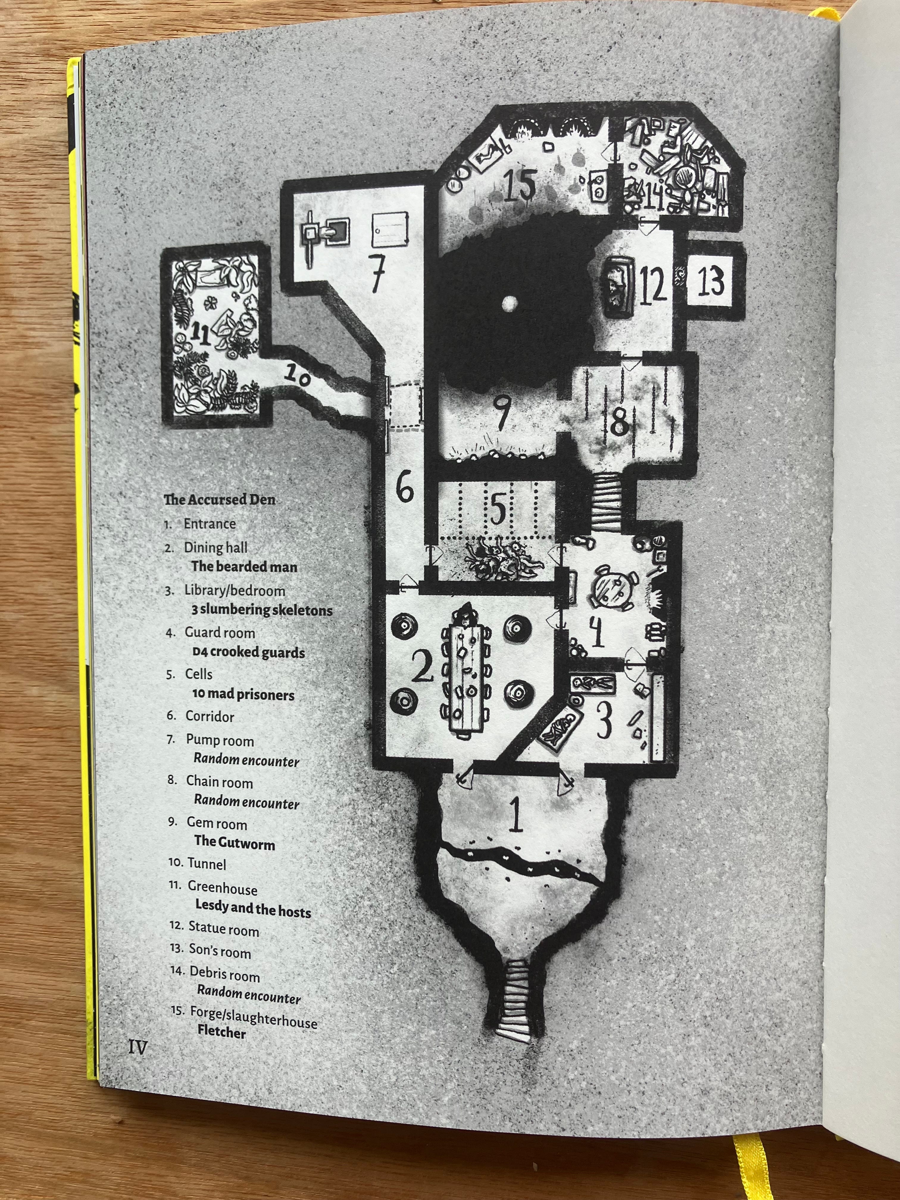
It’s interesting to contrast it with Johan Nohr’s map for the adventure in Mork Borg. Ostensibly a similar space to The Burial Mound, even has a similar gash in the floor, but the effect is completely different, implying a grimy space of dirt and possible horror, enhanced by the chaotic void between 9 and 15. There is no grid. The details are there to convey the atmosphere of the room as much as the logistics. The room structure is actually quite rigid, the lines mimicking a thick marker pen, but absolutely straight, giving the contents more license to be portrayed in a hand-drawn way without the whole becoming too difficult to read. Details like the pile of bodies in 5 or the severed arm in 15 tell you exactly where this adventure, indeed the system itself, is aiming for.
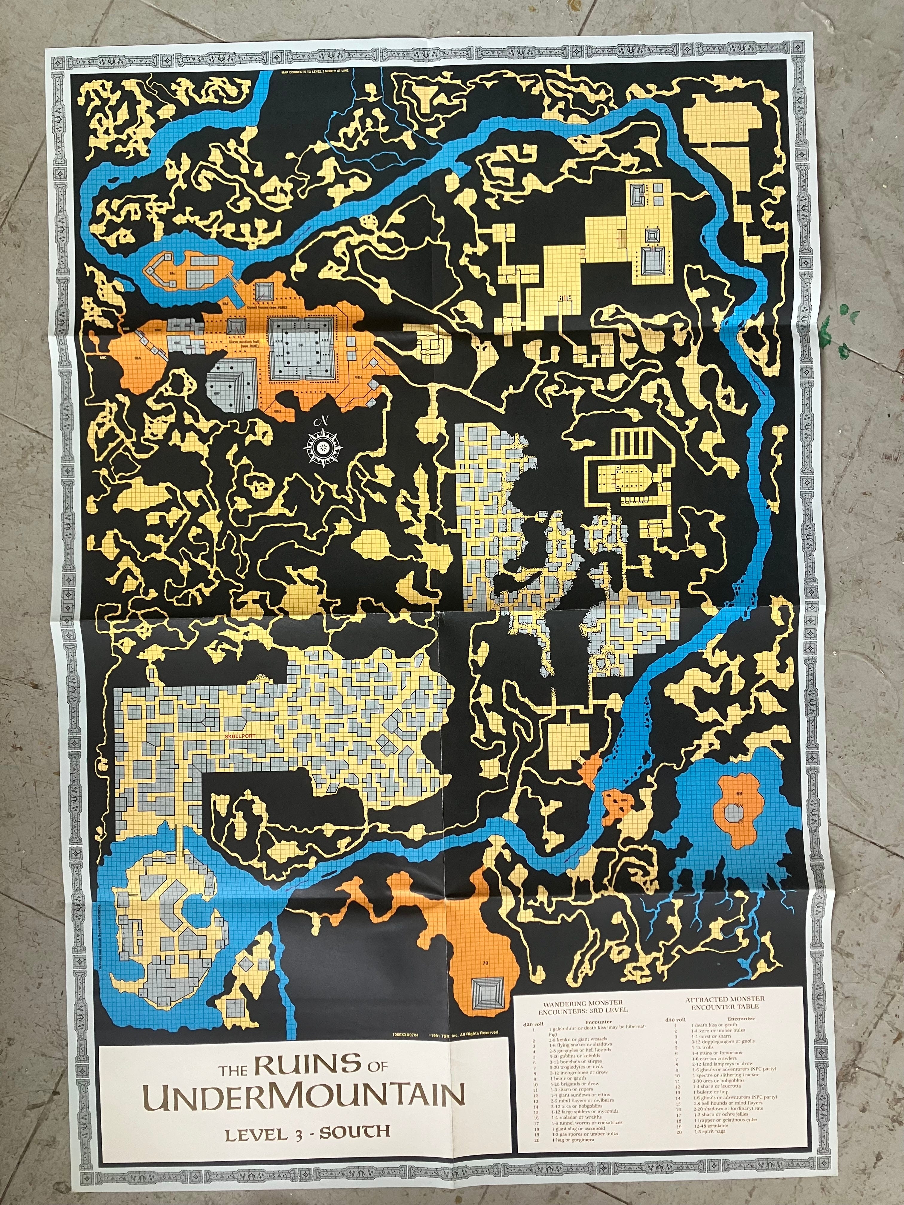
Now a map like this, for TSR’s megadungeon Ruins of Undermountain (1991, for AD&D 2e, by Diesel and Steve Beck based on maps by David Sutherland, apparently), is doing something completely different. Gridded, but overwhelming in its scale. This is just one of the four similar maps that come with with the set, enough material, I would imagine, for years of play. However only a tiny fraction of the areas are actually keyed or labeled (SKULLPORT occupies the southwest of the map, the northwest has a number of keys in one area, with nothing keyed in the northeast at all). This is a structure for a GM to largely fill in themselves, either through encounters, improvisation or extensive prep. This kind of intensity in the image does make me want to explore, and this would be a lovely prop in the middle of a table, but that would mean forgoing the idea of the unknown. It could be fun as an in-world item, a map that the players have found. The detail is sparse enough that there’s plenty left to discover.
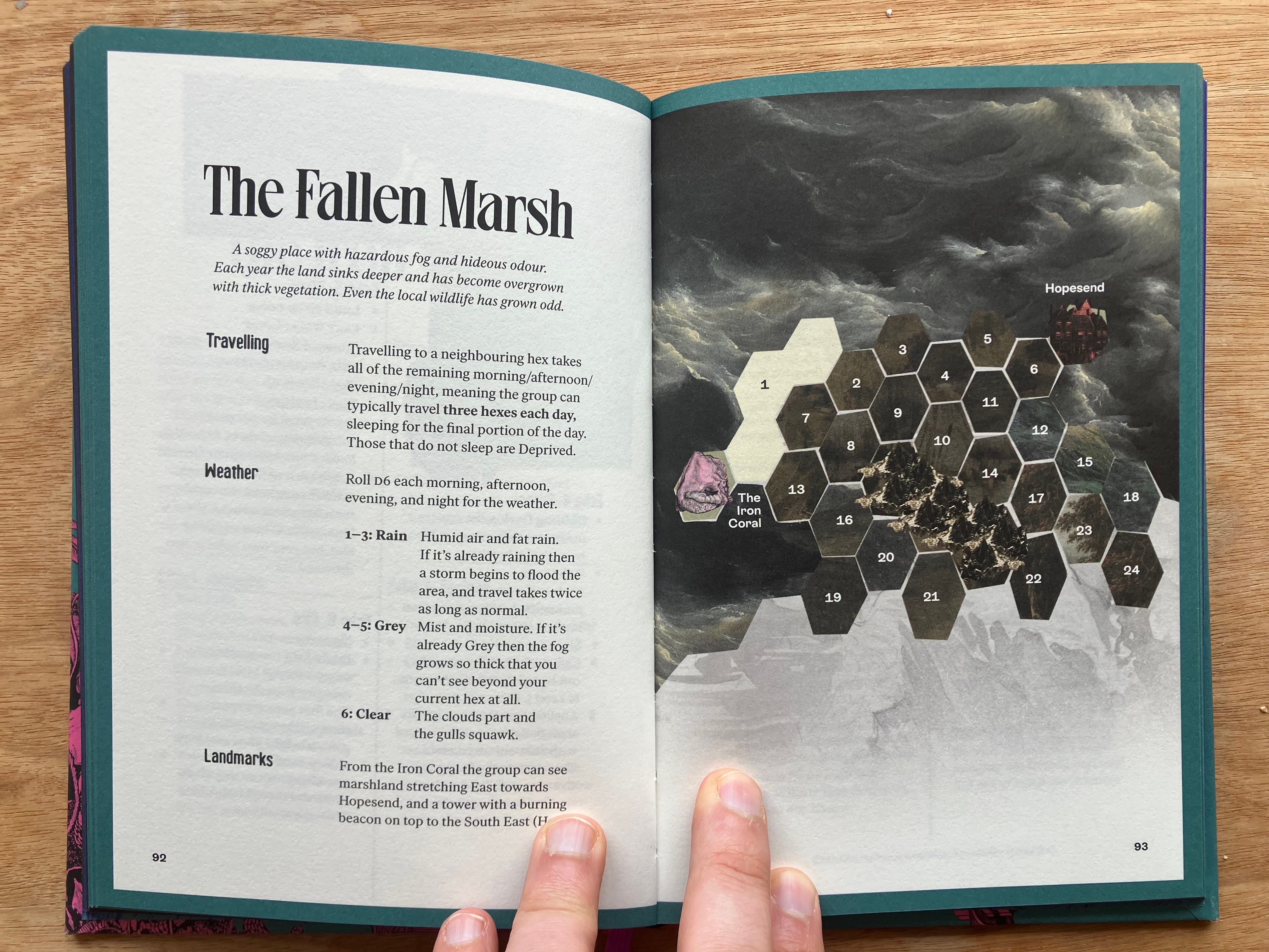
Another map that deals with a large area in a different way is this hexmap for Chris McDowall’s Into the Odd Remaster by Johan Nohr (again!). Rather than mapping out every square foot, here we have an expanse laid out as unknown areas, apart from the elements the players can see from The Iron Coral - The tower of Hopesend and the mountains to the east. The bulk of the page is taken up by a picture of a roiling sea, setting the tone for the watery marshlands of the adventure. Although far less granular than the TSR map, with the keying this holds an enormous amount of adventure in a small space. There’s an anxiety that comes with excessive detail in a map, it creates a truth at a table that has to be obeyed, that the GM has to be continuously faithful to.
The problem with maps
Which brings me onto the problem with maps. Philosopher Alfred Korzybski stated that “The map is not the territory”. It’s a phrase that encapsulates the concept that our ideas, beliefs, or models of the world never exactly match reality. Just as a map will leave out some parts of reality – trees, rocks, changing weather – instead showing only what matters for traveling by road, or traveling by foot, or for nations’ borders, our minds simplify reality to help us understand it.
So all maps leave out details. No map can encompass the entirety of a space. But also, each map encapsulates the worldview or biases of the person who made it. We can see how each map I’ve talked about holds the playstyle within it. Obviously, this can be ignored, but it’s still there. Maps imply a permanence, just like writing down a sentence gives it more weight than one said out loud. Maps in adventures show the state of the world before the adventurers enter it. As soon as actions in the game start to occur, the map is no longer “true”. They might set fire to a building, raze a forest, open a portal, pick up the severed arm and put it in their backpack.
How to use and make maps for our games
Don’t be intimidated by the high production values of many of the maps out there. An arrangement of post-it notes on a page can be just as useful, sometimes more useful when running a game. As a designer, let the map be part of play, encapsulating the playstyle you’re trying to support. If you don’t have gridded combat, you don’t need a grid. It’s always an interesting exercise to see what the bare minimum is to create the experience you want. Would a bit of public domain art alongside a simple point map actually be better for what you’re trying to create?
Maps are never complete. There’s the Borges short story about this called On Exactitude in Science:
“The Cartographers Guilds struck a Map of the Empire whose size was that of the Empire, and which coincided point for point with it… In the Deserts of the West, still today, there are Tattered Ruins of that Map.”
Give space in your maps for imagination and change. The map is not the truth at the table. Even imaginary worlds change in unexpected ways.
I guess what I’m trying to say is, make your own maps, in your own style. The act of thinking them through will make them more lived in, more flexible, more real.
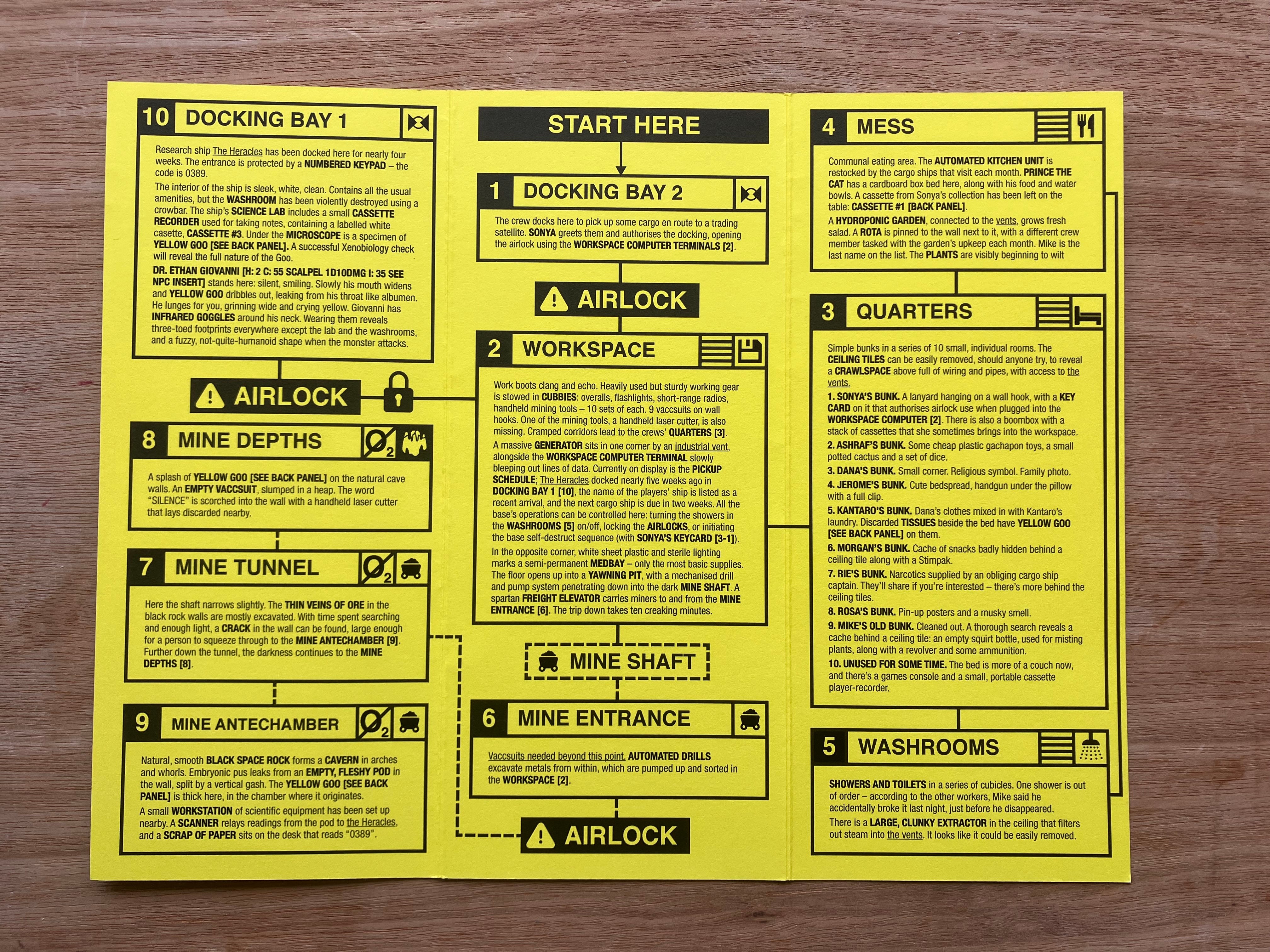
I’ll leave you with this last example, the map from the Mothership module The Haunting of Ypsilon 14, written by D. G. Chapman and mapped by Sean McCoy. In this map, the map is the module, each space combined with the text about it. It even has 10 areas, so that with a d10 you can discover where the Haunting is. It’s so smart. I’m very jealous. The details of the icons, vents and oxygen level are delicious.
It could be that all maps shared the trait of "approximation"; though, what exactly they're trying to approximate might be the main difference between any two.
Always enjoy reading your posts to get me thinking.
There’s so much to explore with maps reflecting the biases of the cartographers who made it too. Maps can be propaganda- you could give your players two maps- one created by the empire that bloats its own size and the size of its colonies and allied nations and minimizes the size of its enemies, and then they find another map that’s more geographically accurate and might reveal some clues to rebel hideouts or natural resources that the empire wants kept hidden so it can extract it all itself. Really fun ways of diegetic lore dumping, not to mention a way to surprise your players when they find the map they have is wrong or misleading in some way.